
Update: Hurricane Hilary Tracking Map from the U.S. Naval Research Lab
PROJECTIONS FOR ENSENADA, MEXICO and SAN DIEGO AND LOS ANGELES, CA.

Please share this post with everybody you know in Baja and the Southwest of the United States.
General Information
Hurricanes involve a million cubic miles of atmosphere. As a hurricane DROPS in category, its tight spiral spreads out, dumping rain over a wider and wider area for longer and longer periods of time.
What most often kills is flooding, not wind. As the storm landfalls, it will slightly slow down, dumping massive amounts of water and will likely cause life-threatening flooding in Ensenada, San Diego, and Los Angeles. Then it may speed up as it makes its inevitable poleward turn due to the Coriolus Effect.
Hurricane Hilary
Heads up, Ensenada and Punta Banda, Mexico, and San Diego and Los Angeles, California.
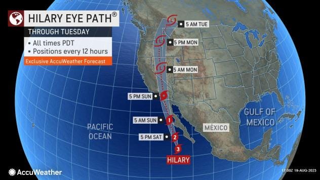
THE TRACK HAS CHANGED SINCE THIS MORNING:
Hurricane Hilary is expected to make landfall 200 miles south of Ensenada and then take a more easterly path in the mountains rather than running straight up the coast. This will help slow the hurricane, shred its eye, and take down the winds.
Category Sustained Winds
1 74-95 mph 64-82 kt 119-153 km/h
2 96-110 mph 83-95 kt 154-177 km/h
Hurricane Hilary will be a Category 1 hurricane when she passes east of Ensenada. Rains will be torrential, but winds will NOT be as severe as previously thought. Still, these are hurricane-force SUSTAINED winds with gusts into the Category 2 range.
This track puts the time of the storm's passing through Ensenada around mid- to late-afternoon on Sunday—though high winds and drenching rainfall will begin to affect the area hours before that. It puts passing to the east of San Diego and Los Angeles Sunday night. Effects will last for hours and hours after the storm has passed, and potential rains for all Baja-Southern California areas are projected to be torrential.
Thank you, this was great information, I recently read another post about moon and tide patterns that indicated this month would be one to watch for flooding and sure enough!